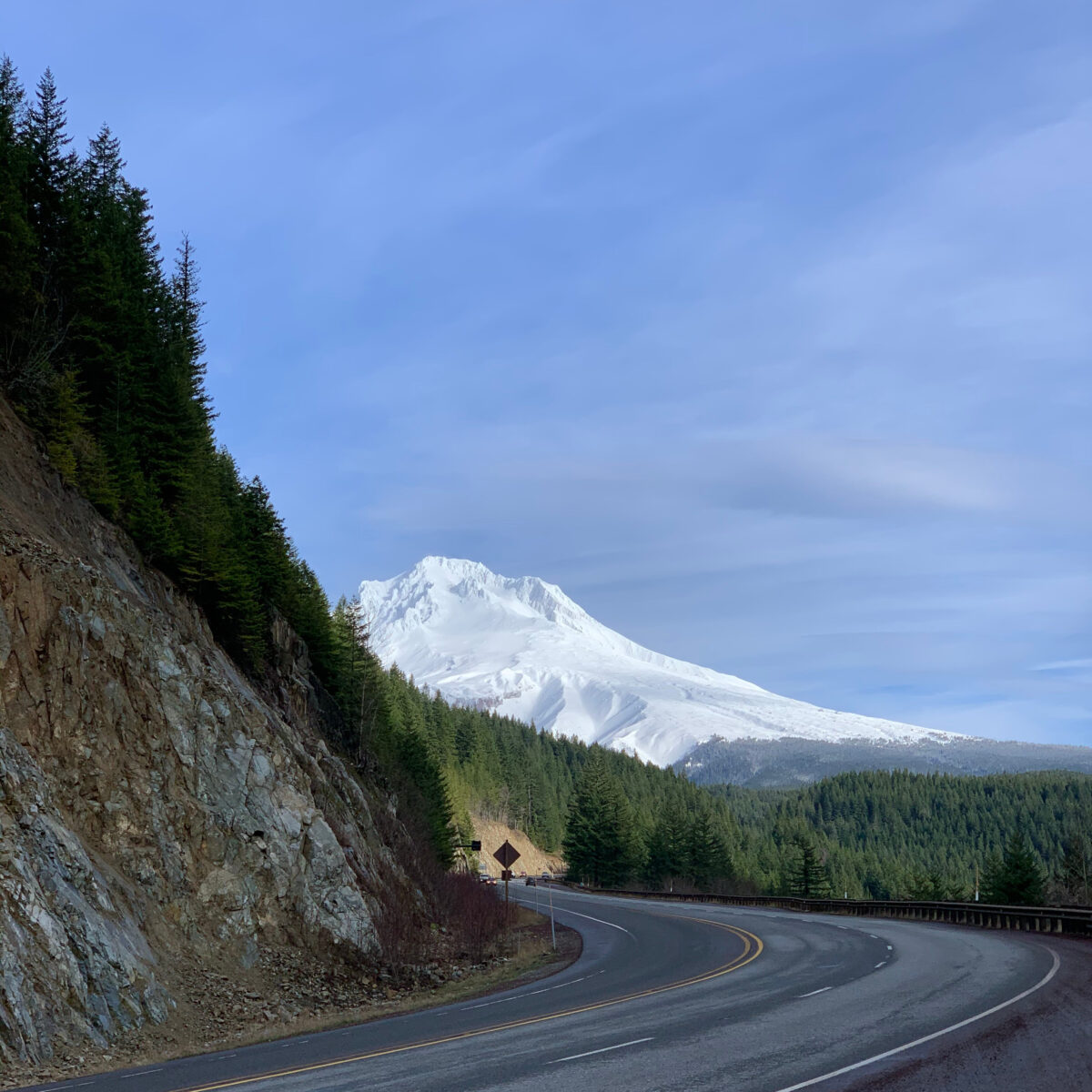
One of the most special drives in Oregon has to be the approach to Mount Hood. This drive provides the traveler with an experience of the best parts of this state we love: old growth forests, waterfalls, dramatic mountain views, and volcanic topography. And then there is the hiking… and biking… and stories! Did you know the Oregon Trail came right through here? And that it is one of the oldest tour routes in the state? Well I am going to have to break up this trip into multiple posts because there really is just too much to share, this first part will cover only 20 miles of the journey. I will be back for more later.
This segment and so much more is best heard and experienced on our GPS audio tour app of the Mount Hood National Forest. Together Anywhere has a separate app highlighting the Central Cascades of Oregon. The interactive map below displays highlights of the various tours Together Anywhere has created. The maroon colored points are the ones described here.

Driving east on Highway 26, we cross into Clackamas County, named after the Clackamas Indians, who were part of the Chinookan people. Clackamas was one of the original 4 districts of the pre-state Oregon Country established in 1843. Clackamas County’s Mount Hood Territory contains many rivers, numerous lakes, 50 parks, and over one thousand miles of trails. I won’t have time to tell you about all that there is to discover here. But the website, MtHoodTerritory.com has in depth information on the abundance of year round recreation opportunities including several foodie and farm trails and an informative historic heritage trail app. My hopes are only to keep things from becoming boring, but if you like Boring, the town is just off the exit ahead. Boring takes its name from a pioneer settler whose family established here in 1856. Interestingly, the town sits upon a 2.6 million year old lava field and has nearly 80 extinct lava vents.
One notable place in Boring is the North American Bigfoot Center. The legend of Bigfoot has created intrigue, entertainment, merchandise, and controversy surrounding the fact or fiction debate for centuries. Have you ever seen the 100-episode show ‘Finding Bigfoot’ on Animal Planet? One of the four cast members, Cliff Barackman, known for his scientific mind and research skills, opened this gift store and partially free exhibit hall in 2019.
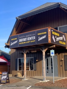
It is located to the left after you take the exit ramp, near the Shell gas station. With his detailed displays of Bigfoot photos and data, you can finally, once and for all, determine for yourself, if the legend of Bigfoot is real.
Boring isn’t so boring after all, is it?
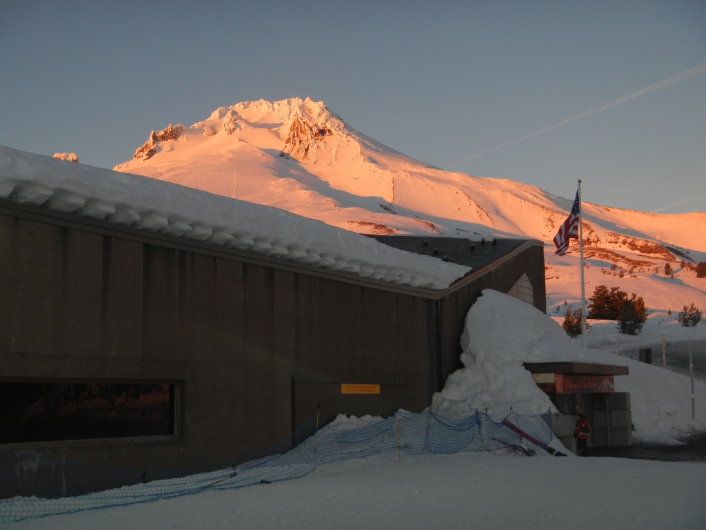
As we approach the city of Sandy, we will gradually slow down all the way to 25 miles per hour. After a few stop lights, I will point out a turn to a scenic overlook called Jonsrud Point. This is one of the best places to photograph Mount Hood on a clear day. If the skies are favorable and you have a few minutes to spare, I recommend a stop. I also have a story and some tips to share as you make your way to the viewing platform.

When the first emigrants happened upon the bounties of Oregon, there was no computer or internet, no phones, no light bulb, no antibiotics, no refrigerators, no cameras, and certainly no cars. So how did people get around? The Native Americans and early settlers went by foot, horse, and boats. In 1845, the first Oregon Trail families found a way to bring wagons around the mountain. I will tell you more of the famous, or infamous, wagon trail on our return trip as this paved the way for the road we travel today. Around one hundred years ago, automobiles took over the roads and in 1925, this highway was officially opened. Tourism only stopped briefly during World War Two. Since then, it has been on the rise and Oregon tourism now generates over $12 billion dollars a year. There are many positive and negative impacts resulting from increased visitation. More dollars mean improvements to the infrastructure and thriving businesses but it often brings with it overcrowding on roads and in parking areas, disturbances to the environment and ecosystem, and local frustrations.

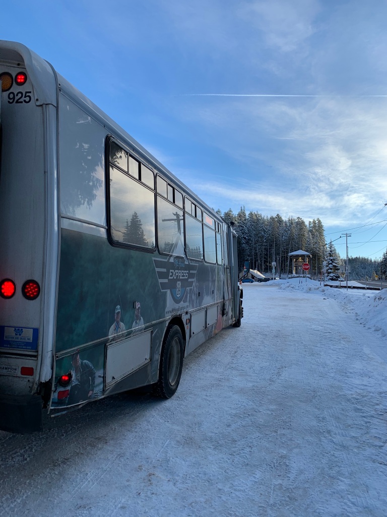
If you have the chance, I encourage you try out the Mount Hood Express transit bus that runs seven days a week, multiple times a day from Sandy all the way to Timberline Lodge and back. The first hop-on point is on Champion Way turning right as you see a Fred Meyer. The free parking area is just across from the cinema. For just a few bucks a trip, or a little more for a day pass, you can explore the communities and popular stops along the corridor without contributing to the road and parking congestion. The busses are equipped with bike trailers and ski boxes for storing your recreational equipment as well. Another pick up location is at Centennial Plaza near the Sandy Historical Society building. However here, there are fewer opportunities to park a car for the day. Other car free initiatives include the carpool matching tool “Get There Oregon”, the Timberline Resort Shuttle running from Government Camp to Timberline, the Skibowl Village Shuttle, the Meadows Park and Ride and the Green Dream Bus from downtown Portland to Meadows ski area, in addition to various other charter services. The remainder of our drive today matches the route of the Mount Hood Express. I really hope you consider these options either today, or in the future, for contributing to a greener Oregon.
Here we are in Sandy, Oregon, also known as the Gateway to Mount Hood. The one way Pioneer Boulevard first passes the Sandlandia Food Carts, then several other outdoor and outfitter shops, the amazing Thai Home restaurant, multiple coffee stops, and eventually, Joe’s Donuts, the red and white checkered building that deserves a stop either now or on your way back from the mountain. The Sandy Mountain Festival is host to over 100 artists during the second weekend of July while seeing 30,000 visitors to this city of 10,000 residents. Sandy Area Metro is the city’s extensive public transit system, connecting all the way to the Portland TriMet’s Max light rail station back in Gresham. This, combined with the Mount Hood Express, means that travelers can go from downtown Portland or the Portland airport to Timberline for less than ten dollars. Public transportation at its finest if you ask me, and we can always use more of that. In fact, there is another pickup for the Mount Hood Express at the Centennial Plaza, on the left side of the road just near the beautiful cabin-like Sandy Historical Society Museum.
The museum is a great stop for history and tourist information. Sandy, named after the nearby Sandy River, is the last incorporated city on Highway 26 heading east for nearly 100 miles. Madras, in Central Oregon, is located on the other side of the Cascade mountains and has a drastically different climate and landscape ….which I’ll get into later. So stop in Sandy and stay for awhile unless you’re ready to dive into the Mount Hood National Forest. My introduction is just a few minutes down the road…and I can’t wait to share what I have in store for us!
Assuming traffic and weather are just right, it would take about 45 minutes to get to Timberline Lodge and Ski Area, nearly 6,000 feet up the mountain. However, I really urge you to take your time traveling down this stretch of highway. Not only is there much to do in this area, it is also one of a handful of safety corridors in the state. Typically, this means that the accident and fatality rate is over 150% of the average for a similar highway and extra safety measures have been taken. As the signs request, please turn your lights on and stick to the speed limit. This area has many unforeseen obstacles, like changing speed limits, changing number of lanes, pedestrians, bicycles, cars, trucks and buses turning on and off the highway, and of course, the impact of snow in high elevation areas.

Government Camp, less than 30 minutes away, receives 87 inches of rain and 246 inches of snow each year. Let’s compare that to Central Oregon on the other side of the Cascade mountains. Bend receives about 10% of that rain amount and only 8% of that snow. If you make it to the east side of the Cascades, you will notice a dramatic shift in the landscape. Different trees, different animals, and a very different climate. What this really means is that more than half of the year, there is some kind of precipitation happening on the mountain. This is a good thing for those who love the lush, green forests in the summers and super sick dumps to rip your way through the pow pow in the middle of the winter. No matter what the weather, I always find tripcheck.com to be a helpful resource when heading out on Oregon highways. Even with all of this precipitation, the summers can be quite dry. Every year, area residents and the forest services are on high alert for the threat of wildfires. Between lightning strikes, abandoned campfires, and other human events, the potential for wildfires is high during most Oregon summers. Initiatives like keeporegongreen.org and the US forest service’s famous 75 year old spokesman, Smokey Bear, do their best to educate visitors each year. “Remember… only YOU can prevent forest fires.”

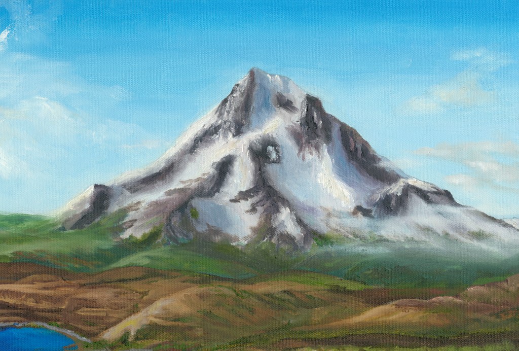
I hope it is one of those sunny Oregon days when the mountain is out. There are just too many great views of Mount Hood on the drive to direct your attention there each time. Plus, if it is snowy or raining, me talking about a mountain you can’t see behind the clouds would just be mean! I’ll leave the mountain view excitement to you in the car and instead tell you what I can about the Mount Hood National Forest, a great destination for all types of weather… if you have the right gear with you. The 1.1 million acre Mount Hood National Forest is one of the most visited forests in the United States welcoming over 4 million visitors annually. The national forest sits in six Oregon counties, offers numerous recreational opportunities, and provides drinking water for over one million Oregonians. There are eight Wilderness areas within the Mount Hood National Forest covering over 30% of the land such as the Bull of the Woods Wilderness. These Congressionally designated areas attempt to reduce the human impact on the land and wildlife, by prohibiting access to motorized vehicles and equipment. Outside of the wilderness areas, you can find one hundred developed campsites, navigable forest roads, motorized boating opportunities, and unique places like Timberline Lodge. The lodge is actually owned by the United States government and the facility is leased on a continual basis.
Fun fact: Oregon has more forest roads than any other state with almost 71,000 miles belonging to the National Forests. That amount is three times the circumference of the earth! The next closest is California with 26,000 less miles to worry about. Maintaining roads is a difficult task for any state but when there are tens of thousands of miles, the amount of work is enormous. Forest roads are notorious for downed trees, road washouts, and rock falls in the spring and summer. In the winter and early spring, I wouldn’t even risk the chance of getting stuck or lost and, thankfully, most roads are blocked off and closed during these times of year. No matter what the weather, I really recommend that you check with rangers at the Zigzag Ranger Station if a forest road adventure or wild camping trip is in your future. If you are planning on spending any time outside of commercial entities, like going on a hike or visiting any national forest designated area, you should have a Northwest Forest Pass or Interagency Annual Pass in your vehicle. And between November 15 and April 30, You are required to display a valid Sno Park permit behind the windshield of your vehicle when parking at designated winter recreation areas like Timberline Ski Area or any sno park.

At this point in the drive, the Mount Hood Highway is right alongside the Sandy River. This river was shortened to be called “sandy” after it was named “Quicksand River” by the famous explorers Merriwether Lewis and William Clark in 1805. They noted that the bottom of the river was unable to be walked across, as it had sand deposits at the mouth. This was the result of 18th century eruptions that had flowed all the way to where it joins the Columbia River. Along with the Salmon River, the Sandy River is one of the two nationally designated Wild & Scenic Rivers and originates from the glaciers on Mount Hood. Both rivers are the focal points for many hikes, waterfalls, fishing trips, whitewater boating, and camping. The two rivers meet up ahead in Brightwood near the Sandy Salmon Bed and Breakfast Lodge. You will notice on the map that we will pass through many small communities with names like Brightwood, Welches, Wemme, Zigzag, and Rhododendron.
Since 2006, the former towns have been collectively known as the Villages of Mount Hood. This designation allowed the local residents to form a quasi-government that gives more direct control over the issues that affect them like zoning, transportation and recreation. In fact, they are known as the ones responsible for the establishment of the Mountain Express, now known as the Mount Hood Express shuttle system. On the westbound tour, I will tell you more about the history of these communities. Two notable experiences are located on the other side of the Sandy River after crossing the Marmot Bridge off East Sleepy Hollow road. First is the Barlow Wayside Park, a one and a half mile trail system with a self-guided natural history brochure, an informational kiosk, and interpretive panels. This park receives about twice the annual rainfall amount of Portland and is full of a moisture rich habitat of trees, plants, and wetlands. The park connects to the Sandy Ridge Trail System, with a parking area just a bit further down East Barlow Trail Road. This mountain biking paradise has over 15 miles of multiple loops accessible year round. These two areas are part of the original Barlow Road and, if you don’t already, you will know all about what that means if you are joining me on the return trip down westbound Highway 26 in the future.
We just passed the Sandy-Salmon River merger I spoke about before and crossed over the Salmon River. In just a few minutes, the speed limit will slow to 45 mph and remain low until we pass the community of Rhododendron. Just as the speed limit drops, look out for the Wildwood Recreation Site on the right side of the highway. Here you have a wonderful opportunity to explore the Salmon River’s calm lower section at this day use area maintained by the Bureau of Land Management. Restrooms, picnic areas, a playground, athletic fields, group shelters and kitchens, summertime swimming, fishing opportunities and hiking make this a popular year round destination. The Wildwood Wetland Trail is an easy, wheelchair accessible interpretive boardwalk and gravel trail that highlights the stories of a field naturalist. The Boulder Ridge Trail is a difficult half to full day adventure into the Salmon Huckleberry Wilderness and connects to a larger network of trails towards four thousand foot Huckleberry Mountain. The crown jewel of Wildwood Recreation Site is the Cascade Streamwatch Trail, which features a unique below the surface level viewing chamber where you can observe native fish in their natural habitat of the Salmon River. What kind of native fish, you ask? Salmon of course! There are seven species of Pacific salmon and five of them can be found in North American waters. Can anyone name a few? I’ll tell you in just a minute.

Even though the Cascade Streamwatch Trail is a short walk and also wheelchair accessible, I would plan to spend over an hour here as you sit and wait for the elusive salmon to arrive. The fall is your best opportunity when the spawning salmon, like the coho, make their yearly run. While you are at it, maybe you’ll see some wildlife like a beaver or river otter or one of the many bird species in the area… but more on this later. Wildwood’s online information indicates that it is open March through November but I was here in January with no indication of it closing for the season. Don’t forget to have your national park pass in the car or be ready to pay the daily use fee. Did you figure out the fish? The five types of North American salmon are: coho, chinook, chum, sockeye, and pink. Now you know… or maybe you already knew all five. In that case, well done.
Well, that is about it from Boring to Wild(wood). I will pick it up here next time. Happy adventuring and take us along with you next time by just downloading the app!
One reply on “Boring to Wild(wood): A Mount Hood Highway Driving Tour”
[…] post is a follow up to my previous post about Highway 26, ending at Wildwood Recreation […]