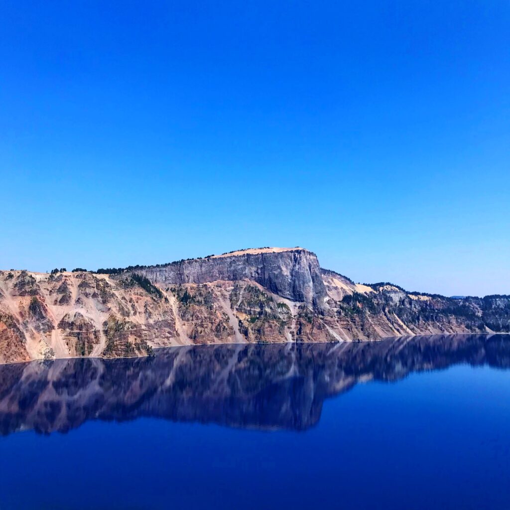
You have no shortage of outstanding views at Crater Lake National Park, Oregon’s only national park and the subject of our newest tour. Want to gawk at the lake’s impossibly blue hue from along the 33-mile Rim Drive, ascend one of the park’s scenic peaks, or even get down to the shore for a truly unique vantage point?
You can do it all—and more. So we wanted to share five of our favorite views at Crater Lake National Park—a few of which show off the different landscapes around the park. Believe it or not, it’s not just about the lake.
First, to make it easy, this audio excerpt from the Together Anywhere Driving Tour of Crater Lake National Park briefly tells you all you need to know. We’ve also included a map of the area for a reference to area highlights.
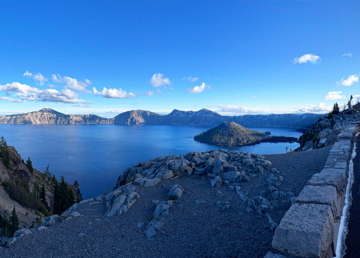
Watchman Overlook
Not all of our favorite views in Crater Lake National Park are of the lake itself—but a few are, so we’ll start there.
Watchman Overlook sits on the lake’s western shore and offers a close-up, seemingly top-down view of Wizard Island. Short of taking a boat tour to the massive cinder cone, this is as close as you can get to Wizard Island.
You can enjoy the view from Watchman Overlook—but if you’re up for a short hike, and if the trail is snow-free, consider a quick trek up Watchman Peak, the towering hillside next to the overlook. This trail gains about 425 feet in less than a mile, ending at the peak’s summit. There you will see a fire lookout that was built in 1932—and is still in use today. The view extends from the lake below to mountaintops in every direction. This is another great place to watch the sunset; in fact, rangers lead sunset hikes up Watchman Peak each summer.
Cleetwood Cove
Cleetwood Cove is home to the only trail in the park that descends to the shore of Crater Lake. After descending a steep trail, you can enjoy a quick swim in the chilly lake or take one of the Crater Lake boat tours to get on the water.
If you’d like to check out Cleetwood Cove, you can park on the north side of Rim Drive. (This is also where you’ll find one of the few rest stops around Rim Drive, just in case you are ready for a bathroom break.) If you want to explore further, follow the crowds across the road and to the top of the trail. From there, you can descend 700 feet in just over a mile to the shores of Crater Lake—the only place in the park you can legally and safely get down to touch the water. Fair warning: The hike back up is no picnic. If you head down to the shore, give yourself plenty of time to get back up—and don’t be shy about plopping down onto one of the many benches along the trail if you need a breather.
Once you’re down on the water, you can dive in and swim to your heart’s content—or until the chilly, 59º degree, or 15 degree Celsius, water is too much to bear. That’ll happen, even on the hottest days in summer.
If you make it to the shore, might I suggest a boat tour or shuttle to Wizard Island? A ranger-led boat tour—the only way to legally get on the water at Crater Lake—explains the lake’s history, its remarkable clarity, Native American legends, and other fascinating stories. I’ve taken the boat tour a few times and learned something new on each trip. Peruse your park newspaper, or check in at the boat tour station in the Cleetwood Cove parking area, to learn more and see about last-minute tickets.
Pumice Castle Viewpoint
On the east side of Rim Drive is a viewpoint that showcases one of Crater Lake’s most distinctive landmarks: Pumice Castle.
As one story goes, a big-city socialite showed up at the park in the early 1900s, having traveled for days and demanding a stay in the Pumice Castle. How disappointed she must have been to learn that the citadel in question was actually a colorful rock formation!
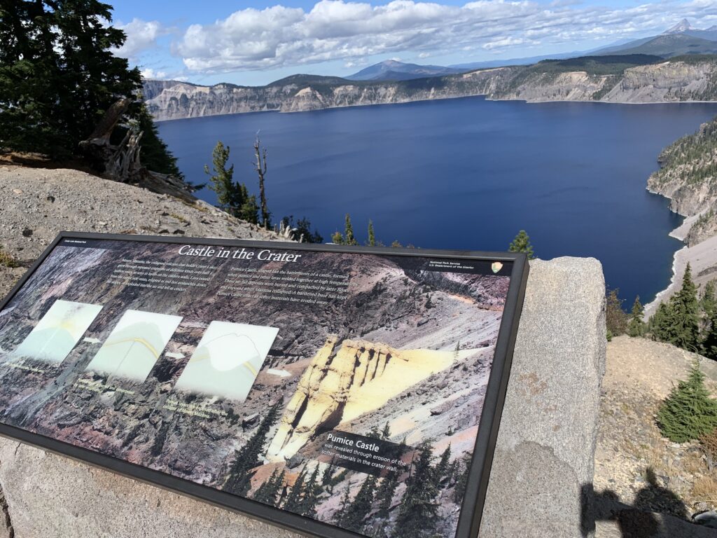
Indeed, the Pumice Castle—named for its vertical spires resembling a mighty fortress— formed when pumice and lava welded together at an exceptionally high temperature during one of Mount Mazama’s eruptions. When the mountain eventually collapsed and softer materials eroded away, the compressed rock was finally exposed. When you get to the viewpoint, look for the Pumice Castle to the northeast, about two-thirds the way up the rim.
It’s an impressive sight whenever you visit, but Pumice Castle is especially striking in the afternoon. That’s when the sunlight hits the rock formation head-on—bringing out those vivid hues of orange and red, creating a nice contrast between the grays and browns around it. On a sunny day, the castle is nothing less than regal.
Pinnacles Viewpoint
From afar, the Pinnacles look like a series of spiky torture devices conjured by a James Bond villain—but there’s a fascinating story behind those needle-like rock formations.
Naturally, it starts with the eruption of Mount Mazama. As the mountain ejected ash, pumice, and lava in every direction, it also belched and burped steam and volcanic gasses that had to escape somewhere.
Vents formed all over the volcano, allowing those gasses to escape through its surface. Once the eruption ended and the expelled hot ash cooled, it hardened into chimney-like fumaroles. Softer material around those vents eroded over the next several thousand years, creating dozens of gray and brown spires. The Pinnacles, as we know them today, were born.
At the end of Pinnacles Road, usually open between July and early October, drivers reach a small turnaround and parking area. Just a few steps beyond the parking lot is an overlook that peers down into the forested valley below. There, visitors can see a forest of 100-foot tall needle-like rock formations jutting up from the hillside.
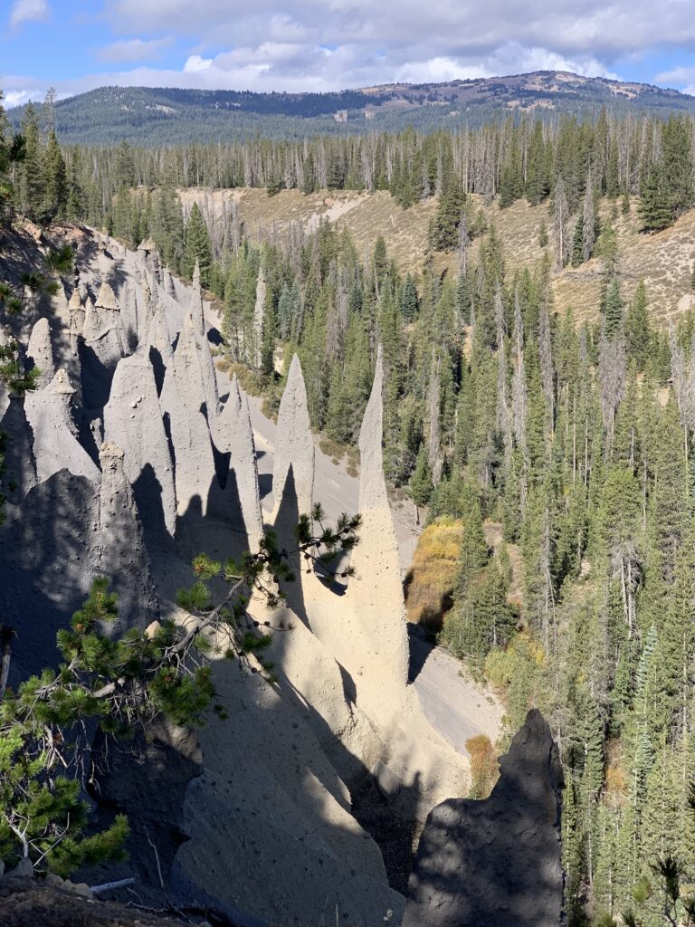
For views of other pinnacles, follow a flat, 0.8-mile round-trip hiking path from the parking area as it heads east through the forest. Just a minute or two from the parking area, a short spur trail off to the left shows an even BETTER view of the Pinnacles in this area. Breathtaking views follow further along the trail; before long, the trail ends at the eastern boundary of Crater Lake National Park—noted by an original weathered signpost made of rock and wood.
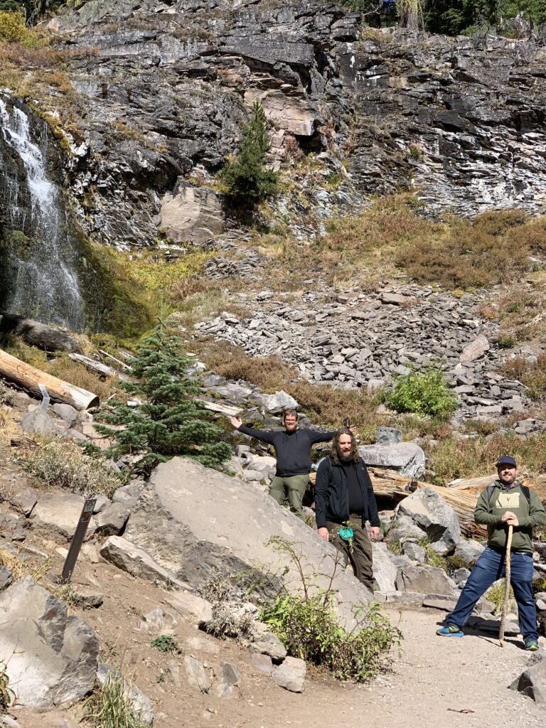
Plaikni Falls
If you’re checking out the Pinnacles Overlook, and if your schedule allows, you might as well stop for a quick, two-mile (round-trip) hike to the base of the scenic Plaikni Falls.
The scenic waterfall, fed by snowmelt and not a leaky Crater Lake, tumbles down a cliffside and into the bubbling Sand Creek below. Colorful wildflowers cover the meadow at the waterfall’s base well into July, and the relative lack of elevation gain—about 100 feet or so—makes it a fun trek for hikers of all skill levels.
The mostly flat trail begins in a sparsely covered forest of fir and hemlock, passing an old access road that once reached the now-closed eastern entrance along the way. The wide path takes a turn at Anderson Bluffs, which once served as a quarry for park projects—such as stone retaining walls alongside Rim Drive.
The trail begins a steady, somewhat difficult ascent soon after as it follows Sand Creek upstream and ends at the base of Plaikni Falls. The out-and-back nature of the trail makes it near impossible to get lost, and the view at the end offers a sight you can’t enjoy anywhere else in the park. If the hike sounds fun, give yourself up to an hour to complete the journey.
Want to know way more?
Together Anywhere has created a way to explore Oregon through stories while driving, remaining separate from other travelers as you go down the road, learning more about this beautiful place we get to live. This post is an example of our tours, except our tours speak to you. You just download the app, choose your drive, and you are on your way!
Our tours are ever expanding around Crater Lake, Central Oregon and Oregon at large!
Tour content for Crater Lake National Park and surrounding area by Matthew Wastradowski for Together Anywhere.
6 replies on “Five fascinating views at Crater Lake National Park”
Wow, what a beautiful view, is it open to the public?
Yes it’s open at both ends, I was there yesterday
very clear and good article easy to understand. Thank you
[…] out our newest Crater Lake National Park Tour and also some recent posts: Five fascinating views at Crater Lake National Park and The secret history of Crater Lake National […]
I hope you plan on developing all your Audio Tours for Android devices. I just downloaded the three (McKenzie River area, Columbia Gorge and Crater Lake) tours. But, noticed I can’t the Fruit Loop tour and others.
Sorry this was your experience! We will look into that. They should all work on Android devices.